

.jpg)


I’m a huge believer in disconnecting every once in a while to enjoy life. That’s where hiking has really helped me—it's my go-to reset button. But just because I’m escaping the digital world doesn’t mean I can’t use a bit of smart tech to make the most of it.
Over the years, I’ve tried a bunch of hiking apps—some incredible, some completely unnecessary. But when you find the right one, it’s like having a mini guide, safety net, and adventure buddy in your pocket.
Here are my favorite hiking apps I think you should try. Whether you're brand new to hiking or you're halfway through your 100th trail, there's something here for you.
Top 9 Hiking Apps Tested & Reviewed — Here's what I recommend
1. AllTrails — Best for Casual Hikers and Weekend Warriors
If you're just getting into hiking or want to explore your local area, AllTrails is probably the first app I’d recommend. It’s got a massive database of trails around the world, with filters for everything from dog-friendly routes to kid-friendly loops.
I love how easy it is to use—you open the app, find a trail, and start walking. You also get GPS tracking, photos, difficulty levels, elevation info, and community reviews.
Tons of useful features for all experience levels of hikers, including interactive rainfall map, pollen or pollution forecasts, severe warning indicators, and a UV index.
If you’re someone who hikes a few times a month and wants a fuss-free way to discover and log trails, AllTrails is your app.

Advantages:
- Super intuitive to use
- Great community reviews and photos
- Filters for trail type, length, difficulty, dog/kid-friendliness, etc.
- Apple Watch integration
Limitations:
- Free version limits map downloads and tracking
- GPS accuracy can be spotty in remote areas
As effective as AllTrails can be, it isn't perfect. The free version of the app is quite limited, and the full suite of features is only available with an AllTrails Pro subscription.
By the way... I was able to sign up for the AllTrails Pro Membership, by using code "Pilotplans25" for 25% off AllTrails Pro. Both this deal is still for a limited time only! Make sure to redeem your discount on the website, as it won't work on your app.
For more in-depth information, check out our AllTrails app review to see if AllTrails will be a good fit for your next hiking excursion. If you're more of an intermediate or advanced hiker and want to know whether AllTrails Pro is worth it, we've got you covered as well!
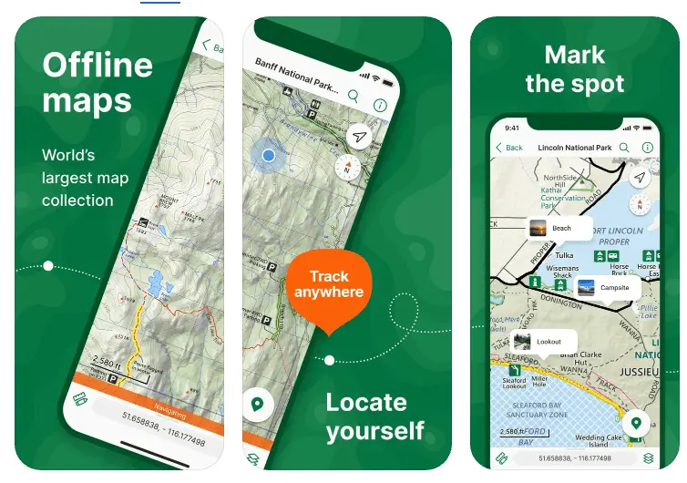
2. Gaia GPS — Best for Backcountry Explorers
Gaia GPS is what I use when I’m heading out into the backcountry or less-trafficked areas. The app offers topographic maps, overlays, weather forecasts, and route planning tools that are seriously impressive.
Even with the free version, I was able to use and find waypoints and look at topographical maps to track routes. With the paid version, I was able to use it offline with a variety of other specialty maps.
While for some, no smartphone app can replace a GPS device or paper map-based navigation, Gaia GPS is definitely the closest I've seen that replicates precise navigation.

Advantages:
- Great variety of map types (satellite, USGS topo, weather, etc.)
- Advanced route planning and tracking
- Offline access with premium
Limitations:
- Not beginner-friendly—has a steeper learning curve
- Free version is very limited
Make sure to read the full review of Gaia GPS if you'd like to learn more about the hiking app or purchase their memberships!
3. Komoot — Best for Route Planning (Hike, Bike, or Run)
Komoot is the planner’s dream app, especially if you're the type who likes to map everything out before lacing up your boots.
You can build detailed routes, customize your start and endpoints, and get turn-by-turn voice navigation—even offline, which has saved me a few times on backcountry trails.
What makes it stand out to me is how specific it gets. You can tailor routes based on your fitness level, preferred surface types (dirt, gravel, etc.), and even whether you're hiking, biking, or trail running. I’ve used it for planning hut-to-hut routes in the Alps and casual city hikes—it works great for both.
It’s not just a map—it feels like a planning toolkit for people who don’t want to leave anything to chance.

Advantages:
- Custom route building with elevation profiles
- Works for multiple sports
- Turn-by-turn directions even offline
Limitations:
- Pay per region unless you buy a global bundle
- Less community engagement compared to AllTrails
4. FarOut (formerly Guthook) — Best for Thru-Hikers
FarOut Guides app, or as I originally knew it as Guthook Guide app, is a hiker's favorite when it comes to long-distance hiking, backpacking, and survival camping.
FarOut Guides is purpose-built for long-distance hikes like the Appalachian Trail or Pacific Crest Trail, where having offline access to detailed waypoints, water sources, and campsites can make or break your trek.
What sets it apart is the real-time community updates on things like water availability, closures, or stealth camping spots—features that go way beyond what standard trail apps offer.
The app is structured around buying individual trail guides, which can be a downside if you’re looking to explore lots of smaller trails. But for people tackling one of the big thru-hikes, it’s one of the most comprehensive tools out there.

Advantages:
- Detailed offline maps and GPS
- Waypoints, water sources, campsites, elevation, etc.
- Real-time community comments
Limitations:
- You have to purchase each trail guide individually
- Not ideal for short or casual hikes
5. Avenza Maps — Best for Park-Specific Hikes
Ever wanted to use those detailed National Park trail maps digitally?
Avenza makes that possible. What makes it stand out is that it works with official, geo-referenced PDFs—like the ones you'd pick up at a ranger station—so you know you're getting trusted sources rather than user-uploaded content.
You can download maps directly from their in-app store, which includes thousands of hiking areas across North America and beyond. In fact, you can also upload or export your own geospatial data, which has tons of implications beyond hiking!
Once downloaded, your GPS location shows up directly on the map even if you’re in airplane mode or have zero reception—something that’s especially useful for remote national or state parks.
You can also pin locations, measure distances, and record your tracks. I’ve found it super useful when I want that extra peace of mind that I’m following official park routes or checking where amenities like washrooms or campgrounds are.
Advantages:
- Works with official, geo-tagged park maps
- GPS works offline (Pro version)
- Great for remote areas
Limitations:
- Many maps cost money
- Interface isn’t as modern or intuitive as newer apps
6. onX Backcountry — Best for Safety-Focused Hikers
onX has a bit of a rugged, pro-outdoors feel to it—and for good reason.
It was originally built for hunters and backcountry explorers, so the level of detail it offers is serious. You get topographic maps, satellite imagery, weather overlays, avalanche forecasts, and tools for tracking your route and marking waypoints.
One thing I really appreciate is the land ownership data, which shows you whether you're on public, private, or restricted land. That’s huge for avoiding unintentional trespassing, especially in areas without clear signage.
It's also great for planning trips where the cell signal is spotty. You can download everything offline—including elevation profiles, trail info, and weather layers—so you're not stuck without data mid-hike.

Advantages:
- Trail reports and weather layers
- Public/private land boundaries (good for backcountry)
- Offline functionality
Limitations:
- More expensive than other options
- Designed more for hunters/outdoors pros than casual hikers
7. PeakVisor — Best for Summit Seekers
I’ll admit it—I used to just call every peak I saw "that mountain over there."
PeakVisor changed that.
It uses AR to identify mountain peaks in real time just by pointing your phone camera at them.
PeakVisor is available for free and with a pro premium subscription. While the free version covers most of the functionalities, the advantage of the pro version is that these features can be used offline without cell service.
PeakVisor is a 3D maps and peaks Identification app that contains information about more than 1 million peaks all over the world and helps you identify the ones you find during your trips.

Advantages:
- Augmented reality mountain ID
- Peak logs and 3D maps
- Offline mode available
Limitations:
- AR accuracy can be affected by lighting/weather
- Better for visual reference than serious route planning
8. Cairn — Best for Staying Safe When Hiking Solo
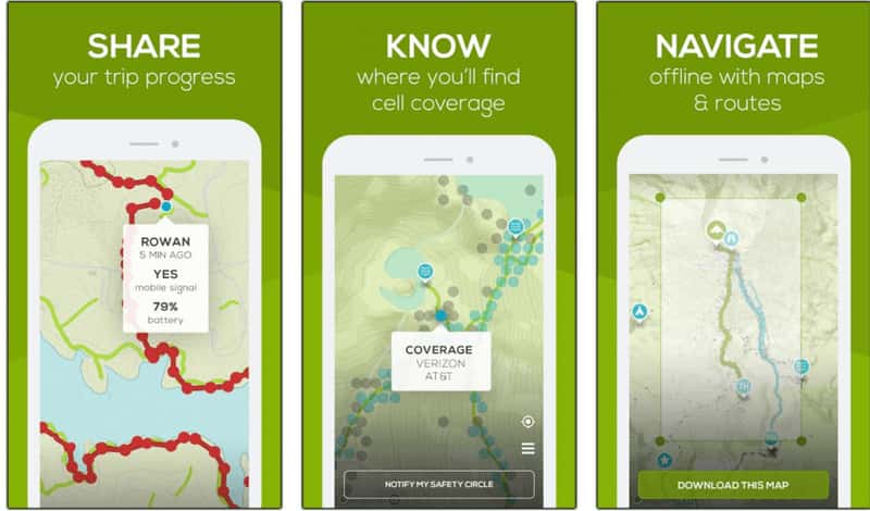
Cairn is an app that focuses on safety and peace of mind when hiking, especially if you're hiking solo.
Cairn gives me peace of mind when I hike alone. It lets me share my real-time location and estimated finish time with friends or family. If I don’t check in, it sends them an alert.
I use the app to share my real-time progress and location with family or friends for their peace of mind and mine, too!
Cairn helps me plan routes by offering helpful estimates of how long I'll take to complete a particular trail based on personalized data and points out areas with weak cell reception.
If it takes longer than expected for your hike, the app also notifies your emergency contacts to make them aware.
The app's premium version lets you use its features offline and automatically sends live updates to your contacts.
Advantages:
- Safety tracking and notifications
- Shows cell coverage on trails
- Helpful for timing and safety estimates
Limitations:
- Key features like offline use require premium
- Not a navigation-first app, more about safety
9. Google Maps — The One Everyone Already Has
Let’s be real—Google Maps is probably already on your phone, and while it’s not made specifically for hiking, it can actually be pretty helpful. I’ve used it plenty of times for casual hikes (tbh more like short walks), especially in city parks or suburban trails.
One underrated feature is the ability to download maps offline, which comes in handy when you're hiking in areas with spotty reception. You can also switch to terrain view to get a better sense of elevation and topography, or use satellite view to see trailheads, parking lots, or nearby rest stops.
While it won’t give you trail-specific features like elevation profiles or hiker reviews, it’s surprisingly useful as a backup or for simpler outings.
Advantages:
- Free & great ease of use
- Offline maps are easy to download
- Useful for planning before/after hikes (like food stops)
Limitations:
- Lacks detailed trail features and elevation data
- Not built for serious trail use

Honorable Mentions: Pokémon GO
In case you need to distract your gamer friend on a hike so they stop complaining or asking, "Are we there yet?"
I believe hiking is fun all on it's own, but when I was looking for a way to spice up my daily walks or treks near the city, I took a "go" with this app. I played the super popular augmented reality game while hiking: Pokémon GO.
Pokemon GO allows you to catch different pokemon, battle other players, and explore different Pokéstops while on your walks or hikes.
If you're not familiar with what Pokémons are, don't worry! The app and community are super welcoming and fast to learn, allowing you to be hooked to the game immediately! And if you catch a shiny, let me know!

Honorable Mentions: Seek by iNaturalist / iNaturalist
For the heroes answering, “What’s that plant/bug?” for the 10th time on the same hike.
Seek by iNaturalist allows you to identify faunas and floras on your hike based on images you take and your geographic locations by providing you a list of possible species based on the picture and location provided. Now I can contribute to environmental and conservation research on my hikes!
What's even better is that you'll be able to earn badges and achievements with the different species you discover!
Download the iNaturalist app and participate in citizen sciences by reporting the species you see on your hikes! Your efforts will help drive conservation and environmental science research and help protect endangered or threatened species!

Honorable Mentions: National Park Service (NPS)
What better place to receive information about parks than the National Park Services themselves?
The National Park Service App, developed by U.S. National Park Services government agency, contains all of the vital information you'll need to know on all 423 national park units, which include 63 national parks around the United States.
This up-to-date information provided by official government sources will help you navigate the tour trails, places to stay and camp, park & campsite amenities, personalized tour guides, interactive maps, and more!
While the National Park Service app might not have nearly enough features to compete with apps like AllTrails or Gaia GPS, I find it an essential download for the most updated official resource on trailheads and park amenities in the United States.
Oh, and they're free to download!

Go Beyond With These Hiking Apps!
There’s no one-size-fits-all hiking app, and that’s okay. I’ve used most of these depending on the kind of hike I’m planning. Some are great for solo hikes, others for off-grid adventures, and a few just make the journey a bit more fun.
Find the one that fits your style—and then hit the trail.
And if you discover a new favorite, let me know. I’m always looking for the next trail (and the next tool) to explore it better.


